LeCropFollow: Latent Space Planning for Navigation in Unstructured Crop Fields
Unstructured navigational features, such as irregular planting or discontinuities, remain the primary failure mode for under-canopy agricultural robots.
1. The “Information Over-Compression” Problem in Agricultural Robotics
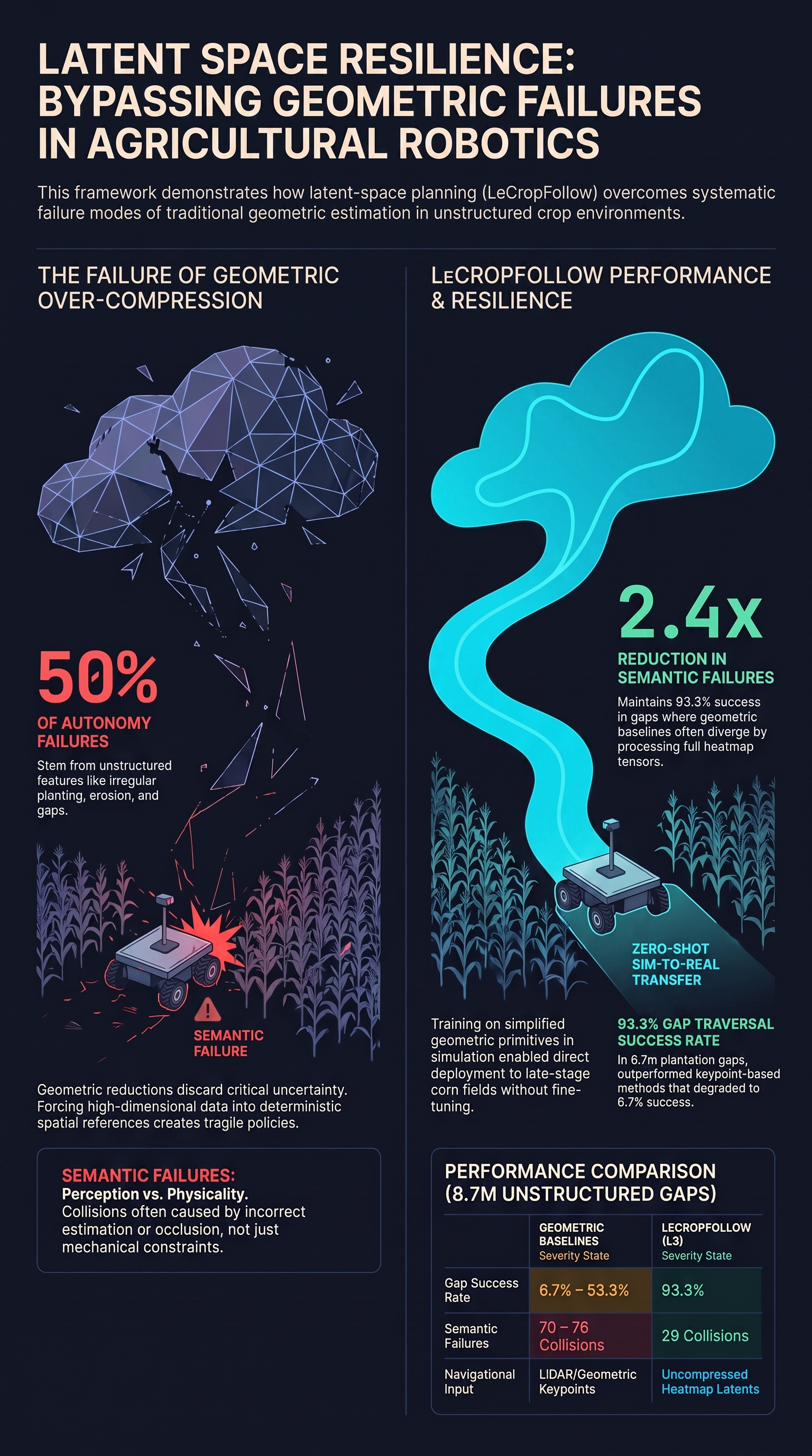
For under-canopy agricultural robotics, navigational reliability is frequently compromised by unstructured environmental features rather than lack of raw processing power. Discontinuities such as irregular planting, erosion-driven row shifts, and significant vegetation gaps represent the primary failure modes in these environments. Tommaselli et al. demonstrate that approximately half of all autonomy failures in these settings are directly attributable to these unstructured features.
The authors argue that the root of these failures is “information over-compression” inherent in traditional geometric pipelines. Such systems reduce high-dimensional visual data into deterministic, low-dimensional spatial references—typically a single pixel coordinate representing a crop row (a keypoint). This reductionist approach discards critical semantic context and measures of uncertainty. When a robot encounters a plantation gap where row references vanish, a geometric system is forced to generate a prediction on ambiguous data. This results in noisy references and divergent behaviors, often leading to catastrophic collisions as the controller acts with unwarranted confidence in ill-posed scenarios.
2. Architecture of LeCropFollow: Bypassing Explicit Modeling
To mitigate the vulnerability of geometric bottlenecks, the authors present LeCropFollow, a visual navigation framework that operates within a learned latent manifold. The architecture is designed to retain the full “heatmap dispersion”—the spatial spread of the perception signal—as a native measure of uncertainty.
As detailed in the system overview, the framework comprises a self-supervised semantic heatmap extractor and a Model-Based Reinforcement Learning (MBRL) planner using the TD-MPC2 algorithm. The perception backbone, RowFollowNet, utilizes a ResNet-18 architecture to produce a semantic heatmap tensor with dimensions of 56x80x3, representing the Vanishing Point, Left Row, and Right Row.
The system processes observations through the following pipeline:
- Perception: Monocular RGB images are converted into the 56x80x3 semantic heatmap.
- Encoding: These heatmaps are concatenated with the robot’s previous actions () into an observation state (). A learned encoder () projects this into a compact latent state ().
- Planning: The system performs online trajectory optimization via Model Predictive Path Integral (MPPI) control. It samples candidate action sequences and evaluates them using a learned world model () and value function () within the latent space.
Crucially for safety researchers, the reward function employs a logistic gating formulation (Equation 4): In this formulation, task-based incentives (such as matching a target velocity) are exponentially nullified by penalty terms for instability () or collision (). This ensures that high-velocity maneuvers are only rewarded when the platform state is demonstrably stable.
3. The Sim-to-Real Recipe: Training on “Harder” Perceptual Regimes
A key contribution of the paper is a sim-to-real methodology enabling zero-shot transfer without field-specific fine-tuning. The authors trained the agent in Gazebo using highly simplified geometric primitives: untextured cylinders spaced at 0.75m.
This deliberate simplicity creates what the authors call a “harder perceptual regime.” Because the simulation lacks the complex visual textures of real corn, the frozen ResNet-18 backbone—which is pre-trained on real-world data—produces noisier, more diffuse activations. By forcing the encoder and planner to navigate based on these degraded, “out-of-distribution” signals, the system develops a robustness that translates to the unpredictability of physical fields.
Furthermore, the authors highlight a critical safety advantage of world models over model-free RL: the world model is trained using a next-state prediction loss. Unlike the non-stationary return signals used in model-free approaches, this prediction loss provides a stable training signal, which is essential for learning to handle rare but critical edge cases like sudden crop gaps.
4. Field Trials: Resilience in Unstructured Gaps
Field evaluations were conducted in late-stage corn plantations during Flowering and Harvested stages. While LeCropFollow matched state-of-the-art baselines in continuous rows, its superiority became evident in the “Plantation Gap”—an 8.7-meter discontinuity where the left row structure disappears.
The following table compares LeCropFollow against the CropFollow++ (geometric) and CROW (LiDAR-based) baselines across 12-15 trials:
| Method | Gap Success Rate | Avg. Collisions (Flowering) | Max Dist. w/o Collision |
|---|---|---|---|
| CropFollow++ (Geometric) | 6.7% | 5.3 ± 1.6 | 38.9 m |
| CROW (LiDAR) | 53.3% | 6.5 ± 1.4 | 37.9 m |
| LeCropFollow (Latent) | 93.3% | 5.1 ± 1.8 | 38.9 m |
LeCropFollow achieved a 2.4x reduction in semantic failures compared to keypoint-based methods. In regions of high uncertainty, the latent planner utilized the spatial dispersion of the heatmap to maintain a smooth heading, whereas geometric controllers drove the robot into adjacent rows by over-relying on noisy keypoint modes. Ablation studies (Fig. 7) confirm that performance “collapses” when the planner is removed () or the horizon is shortened (), proving that latent-space trajectory optimization—not just the representation—is the primary driver of failure resilience.
5. Decoding Failure: Semantic vs. Physical Categories
The paper provides a technical post-mortem by categorizing collisions into Semantic and Physical failures, using specific telemetry thresholds to identify the root cause:
- Semantic Failures:
- Perception Errors: Incorrect estimations resulting in minimal corrective signals (< 0.2 rad/s).
- Occlusion: Loss of visual tracking identified by high-uncertainty signals and heading spikes (> 45°).
- Physical Failures:
- Actuation: Inability to track trajectories, marked by actuator saturation or high control variance (> 0.6 rad/s).
- Terrain: Heading deviations triggered by ground irregularities, identified by IMU roll/pitch spikes (> 25°).
- Bad Start: Immediate divergence within the first 5 meters.
LeCropFollow significantly outperformed baselines in reducing Semantic Failures (29 total vs. 70-76 for baselines). However, the authors acknowledge that Physical Failures related to vehicle-terrain dynamics remain a limitation. Severe uneven terrain can still induce mechanical heading spikes that purely visual planning cannot currently mitigate.
6. Conclusion: Implications for Robust Embodied AI
The work of Tommaselli et al. provides a compelling case for latent space planning as a robust alternative to geometric estimation in heterogeneous environments. By avoiding the deterministic “information over-compression” of visual data, LeCropFollow preserves the semantic context and uncertainty measures required to navigate the discontinuities that typically cause autonomous system failure.
For AI safety practitioners, the stable next-state prediction signal of the world model and the mathematical prioritization of safety via logistic gating offer a blueprint for building more resilient embodied agents. Future iterations may further enhance robustness by integrating complementary sensing, such as depth data, directly into this latent-planning framework.
Read the full paper on arXiv · PDF