MIL-LC: A Robust Magnetometer-Inertial-LiDAR Fusion Multimodal Localization Framework
Localization in challenging environments, such as GNSS-denied, geometrically repetitive, or textureless scenes commonly found in offices, hotels, and underground parking facilities, remains an open...
1. The Localization Crisis in Autonomous Systems
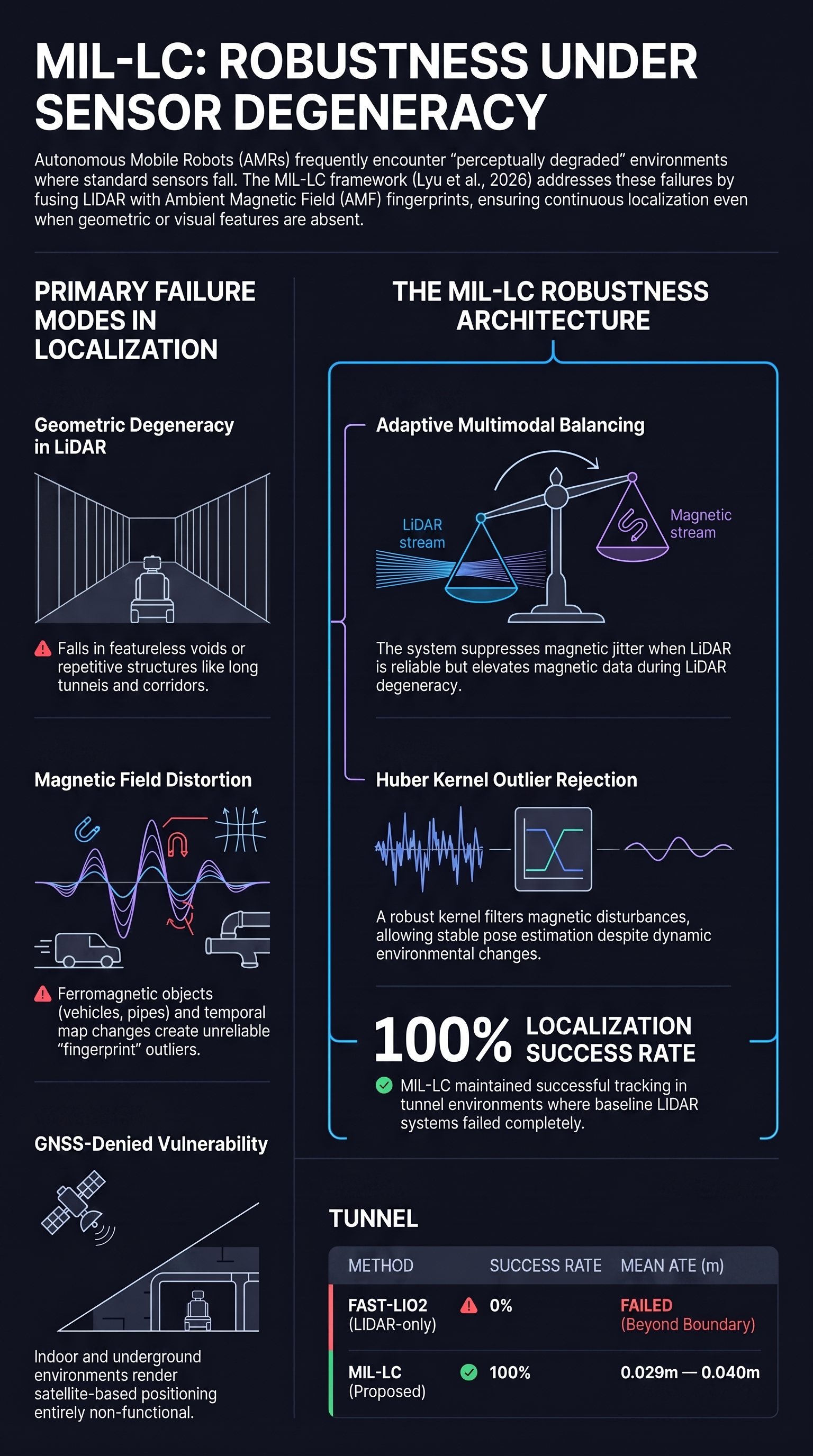
In the deployment of autonomous mobile robots (AMRs), traditional single-modality localization faces a critical “failure gap.” Standard systems—relying heavily on geometric or texture-rich environments—frequently suffer catastrophic failures in “degenerated” scenes. Environments such as featureless vehicle tunnels, repetitive industrial warehouses, and GNSS-denied underground parking garages present “geometric symmetry traps” and “sensor hallucinations” where sensors like LiDAR lose orientation along featureless axes and cameras fail due to weak textures.
The research by Lyu et al. (2026) introduces MIL-LC, a Magnetometer-Inertial-LiDAR fusion framework designed to bridge this reliability gap. By prioritizing a “Failure-First” perspective, the authors propose a system that remains operational even when primary geometric sensors suffer total functional degradation in scenes that evade reliable evaluation by standard benchmarks.
2. The Tripartite Fusion: How MIL-LC Works
The MIL-LC framework integrates three distinct sensor modalities to ensure continuous pose estimation via an Iterated Error-State Kalman Filter (IESKF). The authors deployed this system on a Scout Mini AMR platform using a custom sensor suite featuring eight RM3100 magnetometers mounted on the chassis to provide a high-resolution ambient magnetic field (AMF) profile.
A critical component of this fusion is the data preprocessing stage. The system implements a synchronization and motion undistortion pipeline using both “forward and backward propagation” of the IMU-based kinematic model. Forward propagation predicts the state and accumulates covariance, while backward propagation synchronizes LiDAR points and high-frequency magnetometer readings (≈200Hz) to a common time frame at the end of each scan window.
| Sensor Modality | Inherent Strengths | Specific Failure Modes |
|---|---|---|
| LiDAR | High accuracy (~3cm); stable in static environments. | Geometric degeneration in repetitive/featureless environments (tunnels, corridors). |
| IMU | High-frequency; infrastructure-independent. | Cumulative drift over time; requires constant observation updates. |
| Magnetometer | Infrastructure-free; independent of geometry/texture; utilizes ambient signals. | Low signal-to-noise ratio; limited spatial discriminability; sensitive to dynamic ferromagnetic disturbances. |
3. Ambient Magnetic Fields (AMF): The Secret Weapon for Robustness
Lyu et al. utilize the Ambient Magnetic Field (AMF) as a primary complementary modality because magnetic signatures—distorted by structural steel, pipes, and cables—are ubiquitous. To process these, the authors employ Sliding Gaussian Process Regression (s-GPR). This technique is utilized to infer the posterior distribution of the latent magnetic field, allowing the system to provide continuous spatial estimates from discrete data points.
The process provides a “magnetic fingerprint” that serves as the crucial initial guess for LiDAR scan matching. This multi-modal handoff significantly increases convergence likelihood in challenging, geometrically repetitive scenes.
Magnetic Fingerprints: Location-dependent magnetic field intensity patterns created by static ferromagnetic objects (e.g., structural steel). Unlike visual features, these fingerprints remain stable across varying illumination and geometric symmetry, providing a stable alternative to visual or geometric features.
4. Engineered Resilience: Adaptive Balancing Strategies
The core of MIL-LC’s resilience lies in its ability to self-diagnose sensor health and adaptively reweight inputs.
- LiDAR Degeneracy Detection: The system performs eigenvalue decomposition on the Hessian matrix derived from LiDAR features. If eigenvalues fall below a threshold of 15, the system identifies the specific directions in which the LiDAR is “blind.”
- Magnetometer Outlier Rejection: To handle disturbances, the system uses a Huber kernel and adaptive weighting based on Mahalanobis distance, effectively ignoring magnetic readings that contradict the pre-built map.
The System “Failure-Management” Commands:
- Analyze Hessian Matrix: Execute eigenvalue decomposition on LiDAR features to identify degenerate state directions.
- Redirect Constraints: If LiDAR degeneracy is detected, project the magnetometer’s constraints specifically into those “blind” directions to maintain the pose.
- Suppress Magnetometer Influence: If LiDAR is well-constrained (no degeneracy detected), scale down the magnetometer residual to prevent its lower-resolution data (approx. 10cm) from degrading the high-precision LiDAR estimate (approx. 3cm).
5. Experimental Validation: Stress-Testing the Framework
The authors evaluated MIL-LC across high-fidelity simulations (Warehouse, Tunnel, Seaport) and real-world trials (Walkway, Corridor, Carpark). To ensure high-fidelity ground truth, the magnetic map was aligned with a Leica total-station-based map.
Quantitative comparisons were made against HDL Localization and a modified version of FAST-LIO2 (scan-to-map) to ensure a fair comparison on pre-built maps. In the “Tunnel” and “Seaport” sequences, standard LiDAR-inertial methods failed or produced errors beyond map boundaries. MIL-LC achieved a 100% success rate. In the “Proposed-10” setting, where LiDAR range was restricted to just 10 meters, the system maintained an ATE of 0.024m in warehouse environments (Table I), proving that robustness does not require sacrificing total accuracy.
6. The Three-Month Test: Long-Term Stability and Dynamic Interference
To test long-term reliability, a carpark experiment was conducted over three months. This environment was highly dynamic; the movement of vehicles caused significant “temporal map disturbances” reaching up to 80µT of intensity change.
Reliability Case Study: Long-Term Map Maintenance As documented in Table II, the framework was tested against magnetic maps that were months old. While purely magnetic-based methods like RoSLAC and IDF-MFL saw errors spike or failed entirely when vehicle configurations changed, MIL-LC maintained a stable ATE of approximately 0.043m. By using the multimodal fused trajectory as a reference, the system isolated magnetic changes that did not match the map, turning the sensor into a diagnostic tool for identifying environment changes rather than being misled by them.
7. Conclusion: Implications for Autonomous Reliability
The MIL-LC framework demonstrates that “Embodied AI” safety can be significantly enhanced by prioritizing multi-modal cross-checks. By utilizing the ambient magnetic field—a modality often ignored in robotics—the authors provide a safety net for when geometric sensors hallucinate or fail. While a slight trade-off in absolute accuracy exists when magnetic data is active, the gain in system-wide robustness is paramount for real-world deployment.
Key Takeaways for Red-Teamers and Researchers:
- Infrastructure-Free Resilience: AMF provides a robust alternative to infrastructure-heavy solutions (UWB/RFID) in featureless areas.
- Health Monitoring: Systems must actively monitor sensor “health” (e.g., via Hessian analysis) rather than blindly fusing data.
- Initial Guess Importance: Using magnetic localization to provide a starting point for LiDAR prevents the “kidnapped robot” problem in repetitive environments.
- Long-Term Diagnostic Capability: Multimodal fusion allows a system to operate through environmental changes (like moving cars) that would otherwise invalidate single-modality maps.
Source Note: This report is based on research by Lyu et al. (2026) titled “MIL-LC: A Robust Magnetometer-Inertial-LiDAR Fusion Multimodal Localization Framework.” Analysis provided by Failure First.
Read the full paper on arXiv · PDF